Nepalcalling
Altitude
5416 M
Co-ordinates
28.7967° N, 83.9386° E
Duration
Best Season
Mar-May, Sep-Nov
Activity
8-10 hours walk per day
Trip Grade
moderate to challenging
Trip Overview
Annapurna Circuit Trek: A Journey Through Diverse Landscapes and Cultures
The Annapurna Circuit Trek is one of Nepal’s most iconic trekking routes, offering an unforgettable journey through diverse landscapes, rich cultural heritage, and breathtaking Himalayan views. Encircling the Annapurna Massif, this trek covers approximately 131 kilometers, though distances vary based on route adjustments and transportation use. Traditionally, it takes around 15–20 days to complete, beginning from the lush valleys of Besisahar and concluding in the dramatic Kali Gandaki Gorge. A Trek Through Changing Landscapes One of the most fascinating aspects of the Annapurna Circuit Trek is the transition through diverse geographical zones. The journey begins in the subtropical lowlands, where rice terraces, dense forests, and cascading waterfalls dominate the scenery. As trekkers ascend, the landscape changes to alpine meadows, rocky cliffs, and eventually, the stark, high-altitude deserts reminiscent of Tibetan plateaus. The highlight of the trek is crossing Thorong La Pass at 5,416 meters—the highest point of the circuit. Reaching the pass is a physically demanding challenge, requiring proper acclimatization, but the reward is unparalleled views of the Annapurna and Dhaulagiri ranges, as well as peaks such as Annapurna II, Annapurna IV, and the sacred Machapuchare (Fishtail). The descent from Thorong La leads to the Mustang region, where trekkers are greeted by barren yet striking landscapes and a distinctly Tibetan cultural influence. Another significant geographical marvel along the route is the Kali Gandaki Gorge, the deepest gorge in the world. This section of the trek lies between two towering 8,000-meter peaks—Annapurna I and Dhaulagiri. The windswept valley here offers stunning views and a contrast to the greener areas trekkers pass through earlier in their journey. Cultural Richness Along the Trail The Annapurna Circuit is not just about the landscapes; it is equally a cultural journey. The trail passes through villages inhabited by diverse ethnic groups, including Gurungs, Thakalis, and Manangis, each with unique traditions, languages, and lifestyles. The Manang Valley, home to the Manangi people, showcases traditional Tibetan-influenced architecture, prayer flags, and Buddhist monasteries. A key spiritual highlight is Muktinath Temple, a sacred pilgrimage site for both Hindus and Buddhists. The temple complex, located at 3,800 meters, features eternal flames burning from natural gas sources and 108 water spouts, believed to cleanse sins and bring spiritual liberation. Hindu devotees consider it a significant site of Vishnu worship, while Buddhists regard it as a manifestation of Avalokiteshvara, the Bodhisattva of Compassion. Throughout the trek, visitors encounter ancient monasteries, chortens (stupas), and mani walls engraved with Buddhist prayers. These elements reflect the deep spiritual connection the local people have with their land. Many trekkers also engage with locals in teahouses, where they can experience traditional Nepali hospitality and taste authentic dishes such as dal bhat (lentil soup with rice) and Thakali cuisine.
Detailed Itinerary
Arrival in Kathmandu (1,350m)
Your journey begins with your arrival in Kathmandu at an altitude of 1,350 meters, where you will be warmly received and transferred to your hotel. After some time to settle in and recover from your travel, you will attend a detailed trek briefing that covers the itinerary, safety guidelines, and essential preparations. This is also the moment to review and check your trekking gear and ensure all necessary permits are in place. If time and energy allow, you can step out to explore the cultural richness of the valley with optional visits to iconic heritage sites such as Pashupatinath Temple, Boudhanath Stupa, and Kathmandu Durbar Square, offering an early glimpse into Nepal’s deep spiritual and historical roots.
Drive to Besisahar (760m)
Begin your day with an early morning drive from Kathmandu, heading west along the scenic Prithvi Highway. The journey follows the Trishuli River, offering views of terraced fields, green hills, and small roadside villages that reflect everyday rural life in Nepal. After passing key junctions like Mugling and Dumre, the road diverts north toward Besisahar, where the landscape becomes more rugged and closely follows the Marsyangdi River. The drive typically takes 6–7 hours, including short breaks for rest and lunch along the way. Upon arrival in Besisahar, the administrative center of Lamjung and the gateway to the Annapurna region, check into your lodge, relax, and prepare for the trekking days ahead.
Drive to Chame (2,670m)
Begin your day early with an adventurous 4WD jeep drive from Besisahar, as the road quickly transitions into a rough and off-road track. The journey, lasting 7–9 hours, follows the powerful Marsyangdi River deep into the Annapurna region, offering an ever-changing landscape of river gorges, cascading waterfalls, dense forests, and occasional views of snow-capped peaks. Along the way, you will pass through remote mountain villages such as Bhulbhule, Jagat and Dharapani. Where you can observe the daily life of local communities. The drive itself is part of the adventure, with bumpy trails, narrow cliffside roads, and occasional river crossings adding a raw, thrilling edge to the experience. Short breaks are taken at roadside. By afternoon, you will arrive in Chame, the administrative center of Manang, surrounded by pine forests and Himalayan scenery. After checking into your lodge, you can relax and begin acclimatizing to the higher altitude in preparation for the trekking days ahead.
Trek from Chame to Upper Pisang (3,300m)
The trek begins with a steady ascent from Chame, passing through dense pine and fir forests alongside the Marsyangdi River. The trail gradually opens up to reveal expansive mountain views, including impressive glimpses of Annapurna II and Lamjung Himal. As you walk through small settlements and cross suspension bridges, the landscape starts to feel more alpine and dry. After reaching Lower Pisang, a short but rewarding climb takes you up to Upper Pisang, a traditional village known for its Tibetan-influenced culture, stone houses, and panoramic Himalayan scenery. The trek typically takes around 5–6 hours, offering a balanced mix of forest trails, river valleys, and high-altitude views. Upon arrival, you can explore the village, visit the monastery, and enjoy a peaceful evening while adjusting to the increasing altitude.
Trek to Manang (3,540m)
The day begins with a steady ascent from Upper Pisang, following the higher trail that offers better views and supports gradual acclimatization. The route passes through traditional villages like Ghyaru and Ngawal, where Tibetan-influenced culture is reflected in monasteries, prayer wheels, and mani walls. Along the way, the landscape opens into a wide, arid valley, with fewer trees and more dramatic alpine scenery. You are rewarded with panoramic views of peaks such as Annapurna II, Annapurna III, Gangapurna, and Tilicho Peak. After a lunch stop along the trail, the trek continues toward Manang, where you arrive by afternoon. Upon reaching the village, you check into a teahouse, relax, and spend the evening exploring while allowing your body to adjust to the increasing altitude.
Acclimatization Day in Manang (3,540m)
Spend the day in Manang to allow your body to properly adjust to the increasing altitude while staying active with short hikes. In the morning, take an acclimatization hike to viewpoints such as Gangapurna Lake or hike up toward the Ice Lake for higher elevation exposure and panoramic mountain views. Another popular option is visiting the Himalayan Rescue Association Aid Post, where you can attend an informative session on altitude sickness and safety. After the hike, return to Manang for lunch and spend the afternoon resting, hydrating, and exploring the village, including its monasteries and local bakeries. This balance of light activity and rest helps your body adapt, preparing you for the higher and more demanding sections of the trek ahead.
Trek to Yak Kharka (4,050m)
The day begins with a gradual ascent from Manang, following a trail that climbs steadily through alpine terrain. The trek takes around 4–5 hours, allowing for a slow and steady pace as you gain altitude. Along the way, you pass small settlements such as Gunsang, while enjoying expansive views of the upper Marsyangdi Valley and surrounding Himalayan peaks. As you move higher, the landscape becomes more rugged and dry, with vegetation thinning and trees gradually disappearing. The trail includes gentle climbs and occasional stream crossings, making the journey both scenic and manageable. By afternoon, you arrive at Yak Kharka, a small grazing settlement where yaks are often seen. After checking into a teahouse, the evening is spent resting, staying hydrated, and continuing the acclimatization process in preparation for higher altitudes ahead.
Trek to Thorong Phedi (4,540m) or Thorong High Camp (4,880m)
The trek begins with a steady climb from Yak Kharka, taking around 4–6 hours depending on your pace and chosen destination. The trail gradually ascends through a barren, high-altitude landscape with limited vegetation, following narrow paths along the mountainside. As you gain elevation, the air becomes thinner, so a slow and consistent pace is essential. Along the way, you cross small streams and landslide-prone sections, adding a sense of challenge to the journey. Reaching Thorong Phedi, the base of the Thorong La Pass, you can choose to stop and rest for the night or continue with a steep 1–2 hour climb to High Camp for a shorter ascent the next day. Both options offer dramatic mountain surroundings, and the evening is best spent resting, hydrating, and preparing for the early morning crossing of the pass.
Cross Thorong La Pass (5,416m) and Trek to Muktinath (3,800m)
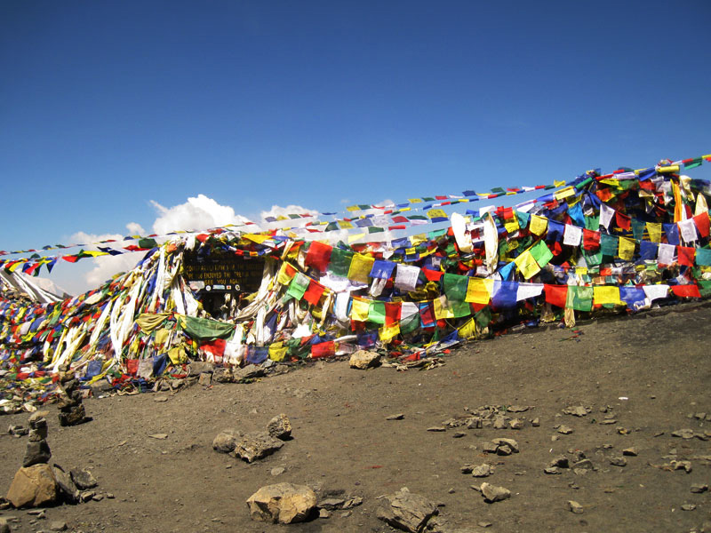
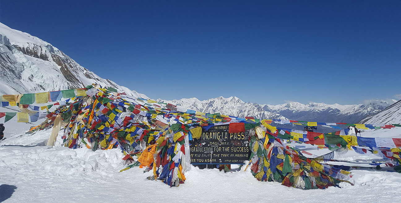
The day begins very early, typically around 3–4 AM, as you set out from Thorong High Camp to cross the challenging Thorong La Pass. The ascent is gradual but demanding due to the high altitude, cold temperatures, and thin air, requiring a slow and steady pace. After several hours of climbing, you reach the summit of Thorong La Pass at 5,416 meters, marked by colorful prayer flags and offering panoramic views of the surrounding Himalayan ranges. After taking in the views, the trail descends steeply toward the Mustang region, where the landscape shifts dramatically into dry, rocky terrain. The descent is long but rewarding, leading you down to Muktinath. By afternoon, you arrive in Muktinath, where you can check into a lodge and rest. If time and energy permit, you may visit the sacred Muktinath Temple, an important pilgrimage site for both Hindus and Buddhists, before relaxing for the evening after a physically demanding day.
Drive to Pokhara (822m)
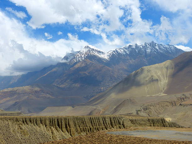
The day begins with an early morning departure from Muktinath, starting a long but scenic drive toward Pokhara that takes around 7–9 hours. The journey descends through the dramatic Kali Gandaki Valley, passing through windswept landscapes and traditional settlements such as Jomsom, Marpha, Tatopani, and Beni. Along the way, the terrain gradually shifts from the dry, arid landscapes of Mustang to greener hills and lush valleys, with views of rivers, waterfalls, and changing vegetation. The road conditions vary, with a mix of off-road and paved sections, making parts of the drive bumpy but adventurous. Short stops are made for meals and rest at local teahouses. By late afternoon or evening, you arrive in Pokhara, where you check into your hotel and unwind, perhaps taking a peaceful walk along Phewa Lake after the long journey.
Photo Gallery
Annapurna Circuit Trek
Trek Highlights
- Diverse Landscapes & Changing Terrains Starts from lush terraced fields and subtropical forests. Passes through deep river gorges, alpine meadows, yak pastures, and barren high-altitude plateaus. Crosses Thorong La Pass (5,416m) – one of the highest trekking passes in the world.
- Breathtaking Himalayan Views Stunning panoramas of Annapurna, Dhaulagiri, Manaslu, Nilgiri, and Tilicho Peak. Gangapurna Lake and glaciers add to the dramatic high-altitude scenery.
- Thrilling High-Altitude Adventure: Acclimatization in Manang (3,540m) to adjust to the altitude. Experience the windy Kali Gandaki Gorge, the world’s deepest gorge. Trek through Thorong Phedi and Yak Kharka, encountering stunning remote mountain landscapes.
- Challenging Yet Rewarding Trek: A mix of steep ascents, river crossings, and high-altitude trekking. Varying terrain from lush greenery to barren, desert-like valleys. Perfect for adventurers seeking a long, immersive Himalayan experience.
- Unique Local Food & Hospitality: Enjoy authentic Thakali cuisine, yak cheese, and butter tea. Experience warm hospitality in teahouses along the route.
- A Once-in-a-Lifetime Trekking Experience: One of the world’s greatest trekking routes, offering both natural beauty and cultural depth. A rewarding challenge for trekkers seeking both adventure and spiritual fulfillment.
- Rich Cultural & Spiritual Experience: Trek through Tibetan-influenced villages like Pisang, Manang, and Kagbeni. Visit Buddhist monasteries, Mani walls, and traditional Gurung & Thakali settlements. Sacred Muktinath Temple, a pilgrimage site for both Hindus and Buddhists.
Culture & Spiritual Heritage
- Deep connection to Tibetan-influenced Buddhist culture, especially in villages like Manang and Upper Pisang.
- Presence of ancient monasteries (gompas), prayer wheels, mani walls, and chortens along the trekking trails.
- Daily rituals and lifestyle shaped by Buddhism, including chanting, incense offerings, and spinning prayer wheels.
- Sacred pilgrimage site of Muktinath Temple, revered by both Hindus and Buddhists.
- Unique blend of Hindu and Buddhist traditions coexisting in harmony across the region.
- Traditional stone-built houses and villages reflecting centuries-old Himalayan architecture.
- Cultural practices of local ethnic groups such as Gurung, Thakali, and Manangi communities.
- Festivals, rituals, and seasonal celebrations rooted in spirituality and local beliefs.
- Strong influence of the ancient trans-Himalayan trade route connecting Nepal and Tibet.
- Sacred landscapes including rivers, mountains, and high passes like Thorong La Pass, often associated with spiritual significance.
What's Included
- Airport pick-up and drop-off in Kathmandu.
- Accommodation in Kathmandu and Pokhara (hotel basis as per itinerary).
- Teahouse/lodge accommodation during the trek (from Besisahar to Muktinath).
- All ground transportation as per itinerary (Kathmandu to Besisahar, jeep to Chame, and return to Pokhara).
- Annapurna Conservation Area Permit (ACAP) and TIMS card.
- Licensed, experienced trekking guide.
- All meals during the trek (breakfast, lunch, and dinner).
- First aid kit carried by the guide.
- Government taxes and service charges.
What's not Included
- International airfare to and from Kathmandu.
- Nepal entry visa fees.
- Travel insurance (including emergency evacuation and medical coverage).
- Personal expenses such as drinks, snacks, laundry, phone calls, and internet.
- Meals in Kathmandu and Pokhara (unless specified).
- Hot showers, battery charging, and Wi-Fi fees during the trek.
- Personal trekking equipment (down jacket, sleeping bag, etc.).
- Tips for guide and porter (expected but not mandatory).
- Any additional costs due to itinerary changes, delays, weather conditions, or unforeseen circumstances.
- Extra accommodation or meals outside the planned itinerary.
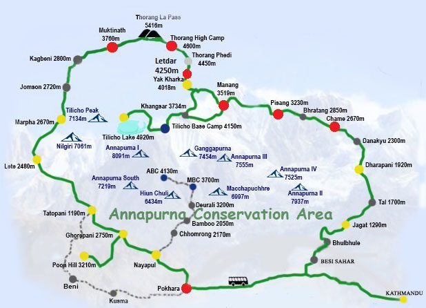
Tour Map
Frequently Asked Questions
Warm layered clothing, good trekking boots, a sleeping bag, snow camprons, rain covers, water bottle, sunscreen, and basic medical supplies are essential.
Limited Wi-Fi and mobile networks are available in some villages, but connectivity becomes weaker at higher altitudes.
A mix of Nepali and basic international dishes such as dal bhat, noodles, soups, pasta, and tea.
Teahouses and lodges are available throughout the route, offering basic rooms and meals.
You need the Annapurna Conservation Area Permit (ACAP) and a TIMS (Trekkers’ Information Management System) card.
Yes, especially beyond Manang. Proper acclimatization and hydration are essential.
It is considered moderate to challenging due to long trekking days and high altitude, especially when crossing Thorong La Pass (5,416m).
The best seasons are spring (March–May) and autumn (September–November) for stable weather and clear mountain views.
Prior experience is helpful but not mandatory. Good physical fitness and preparation are important.
Book This Trip
Contact Information
info@nepalcalling.com
nepalcalling4@gmail.com
Phone
+977-9860680553
+32-0485063791
977-9860680553
Related Trips
Let your travels tell a story—crafted by locals, inspired by mountains, and lived by you.
Join The Nepal Calling Newsletter
Be the first to receive exclusive Nepal tour packages, trekking offers, travel tips, destination guides, and seasonal travel inspiration—delivered straight to your inbox.